
Del Rio Crossing (Draft)
The trail design at Del Rio Crossing does not meet the Secretary of Interior's Standard.
The California State Railroad Museum Foundation comments start at page 709 of the Final Environmental Impact report.
Quoting from the CSRMF comment "7R" on the draft environmental impact report:
Moreover, the Draft EIR correctly notes that certain features qualify the route and rails for inclusion on the National Register of Historic Places, and the "Most Significant" features are the "location and track alignment" and the "Elevated embankment (intermittent)."
Yet, the city proposes to remove the elevated embankment within the urban area where trail users can view and appreciate this feature, all to avoid impacts to roads while creating maximum and irreversible impacts to the historical rails.
The Draft EIR makes no effort to explain how the removal of this significant feature does not result in a significant and unavoidable historical resource impact.
The Draft EIR is inadequate for its failure to consider these issues or to analyze the issues in the manner prescribed by law.

the 575 foot long path of destruction
When the project is completed a 575 foot path of destruction have been carved out of the railroad
In the picture above shows the view when standing just north of to the pedestrian crossing looking north.
In this view the west bank of the levee is on the left and 27th avenue is on the right. It is easy to see that there is plenty of room for a bike trail on the west bank of the levee.
To the south of the pedestrian crossing 225 feet of have already been removed by the city, in order to install some pipes. The levee in this area of removed track still remains relatively intact.
The city intends to continue bulldozing for at least 60 more feet of levee with no tracks on it.
This will make a total of 410 feet of levee completely destroyed with the historic Sacramento Southern Railroad right of then paved over with a bike trail.
The remaining 165 feet of currently trackless levee may also be bulldozed. The preliminary plan is unclear about this, but does specify that the wreckage from the destroyed operational track will be dumped in this area and used for railroad themed landscaping.
350 feet of operational track will be destroyed
350 feet of operational track will be destroyed at Del Rio Crossing
This photo is looking south at the levee and tracks that are to be bulldozed and destroyed. This is the same operational track shown in the last picture but looking in the other direction.
Note at the top of the image the existing pedestrian pathway can be seen in the distance.
410 feet of Historic Right of way will be paved over
West side pedestrian walkway is historic
The west side of the current pedestrian crossing is safe and historic
The ramp on the west side of the tracks is historic. It was probably constructed in 1906 and is believed to be part of the flag stop named Charles. The ramp on the east side of the pedestrian crossing is much steeper and was probably constructed in the 1960's when 27th Avenue was extended to Del Rio Road and a new curve was added to Del Rio Road that had not been part of the historic layout.
Interestingly the west bank ramp is not shown in any of the documentation provided by the City of Sacramento.
This ramp can be seen in another picture
Click the button below to see another view of the ramp at the very top of the picture.
a deceptive image
GPA consulting's view of the pedestrian crossing

This picture is taken from the Final EIR and is frequently displayed in applicant paper work. It was taken by GPA consulting, a company hired by the City to write the FNAE-SC-SIOS.
This image shows the east side of the crossing. The street sign says this is the corner of 27th Avenue and 27th Avenue. This sharp turn and extension of 27th Avenue was added after 1955 and is believed to have been added when I-5 was being built. It is believed that the dangerous turn at Del Rio Crossing was built at the same time.
Notice that in this picture the street sign is not vertical. Not only that but the grade seems to be going steeply up hill. Normally railroad grades appear flat to the naked eye.
The angle of the embankment appears to be much steeper than a 2% grade. This is because GPA consulting tilted the camera angle to distort the image.
Same sign, another view
This same sign is seen in the background in this view. In the foreground is the sold railing of the west bank ramp.
Notice that in this picture the sign post for the sign is vertical. It can be seen that the angle of the sign post is at the same vertical angle as the railing in the four ground. The sign post is also parallel with the telephone pole.
Google Maps shows the levee at the correct angle
Google Maps shows the levee at the correct angle
Google Maps shows the levee at the correct angle
This picture taken from google maps shows the correct angle for the levee as it appears in real life. Note that the Sacramento Southern Right of way on top of the levee appears completely flat. The shadow of the goole map car can be seen on the road way.
The top of the Pedestrian Crossing
Google Maps shows the levee at the correct angle
Google Maps shows the levee at the correct angle
This image is looking south from the top of the pedestrian crossing. South from here the tracks are missing for approximately 75 yards but the levee is still relatively intact.
Old maps show extending normandy lane is a restoration
Dell Rio Crossing in 1955

Note that in this image from the Shell map from 1955 that 27th avenue had not yet been extended into the dangerous three way intersection.
Del Rio Crossing 1913
"Country road" what Del Rio Road back in 1913 used to connect with what is now Normandy which in those days crossed the tracks at a perpendicular angle. in those days what is now Normandy line connected to Portero way. So the proposed extension of Normandy lane would restore Del Rio Crossing closer to its 1913 design.
Alta drive can also clearly be seen in this 1913 map.
Tunnels are the answer and their are two different choices.
A tunnel could be used to replace the pedestrian crossing.

This bike tunnel is in Davis California and goes under the tracks. But there is a better option. Once it is decided that a tunnel is the answer then the best place to put the tunnel is under the new normandy lane extension.
The new Normandy lane connection should be designed to pass over the tracks using modern ADA compliant pre-cast railroad grade crossing panels. This would meet the standard that new construction be clearly distinguished from the old. A ramp from the west side of the old pedestrian crossing could connect with the new crossing at Normandy lane.
Handicapped children could cross over the bike trail tunnel on the new normandy lane extension. The would cross over the tracks at a perpendicular angle over ADA compliant pre-cast railroad grade crossing pannels.
A Tunnel under Normandy lane!
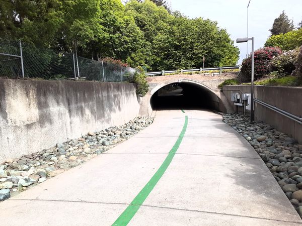
Normandy lane is being extended. The best place to have a tunnel is under the new Normandy lane extension. That way bike riders would have a not stop grade separated rout through this area.
The crossing at normandy lane should be made ADA compliant. ADA compliant ramp could connect the current ramp which is safe but just a little steep to be ADA compliant with the new ADA compliant crossing at normandy lane.
This design will have maximum safety. In the present design bike riders blast down a hill on either side of the proposed new pedestrian crossing. There is a danger that these speeding bikes may crash into the cross traffic may crash into children with mobility issues on their way to school.
Since some of these children might be developmentally disabled they may have difficulty realizing the danger. Neighbors have been expressing a desire for a separate walking path. That plan has been rejected but when it comes to the safety of handicapped children a separate path is the best option.
Now all that remains is the unsafe 27th Avenue. There a number of options here but the best one is to make 27th avenue one way. There are three houses on 27th avenue and the dangerous corner. These people could access their driveways is the north bound lane were preserved.
But the south bound lane presents a huge hazard. There is a danger that cars would not be able to make the sharp turn here and hit handicapped children on there way to school. Now there is an embankment protecting the children. If this embankment were removed then there is a terrible chance that children on their way to school could be hit by people who overshoot the turn.